
Vigorous atmospheric disturbances are set to bring severe thunderstorms, damaging wind gusts up to 80 miles per hour, and heavy rainfall to the Great Lakes and Ohio Valley on July 27, 2026, according to forecasters.
The Storm Prediction Center has issued an Enhanced Risk (Level 3 out of 5) covering major urban areas including Milwaukee, Chicago, and Indianapolis.
>>> California Man Found Alive After Drifting a Month at Sea Near Hawaii
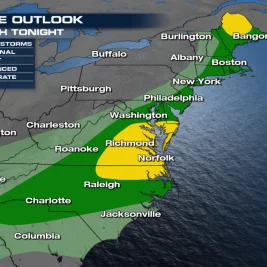
Weather systems moving across northern regions risk triggering flash floods from Buffalo to Boston through Tuesday evening.
Forecast Challenges and Previous Impacts
AccuWeather meteorologist Brandon Buckingham noted the difficulty in pinpointing the exact location of the highest risk due to the fluid nature of the weather pattern.
"Day-to-day thunderstorm activity can sometimes rely on where previous rounds of thunderstorms develop, which makes pinning down the exact location of the highest risk for severe weather difficult until just a matter of hours before storms form," Buckingham said.
>>> US Halts Iran Bombardment as Tensions Escalate in Caspian Sea
The system previously lashed Sioux Falls, South Dakota, with wind gusts exceeding 90 miles per hour, knocking out power for thousands of residents.
Threatening conditions are expected to stretch eastward into the Mid-Atlantic and Interstate 95 travel corridor by Tuesday afternoon.
Concurrent with the northern storm activity, hazardous heat conditions continue across the southern and central United States.
>>> South Korea Raises Heat Wave Alert to Severe as Mercury Hits 39.2°C
Heat index values are expected to range between 105 and 115 degrees Fahrenheit, triggering widespread heat advisories.