
Severe thunderstorms with wind gusts exceeding 100 mph, large hail, and tornadoes swept across the Chicago metropolitan area and parts of the Midwest on Monday, July 27, 2026.
The storms caused widespread power outages, grounded flights, and damaged infrastructure.
>>> Five Lottery Tickets Split Saturday Take 5 Jackpot
Warnings and Damage
Tornado warnings were issued in Cook, DuPage, and Will counties. Trained spotters reported tornado touchdowns in suburban Orland Park and Glen Ellyn.
The National Weather Service urged residents to seek immediate shelter, warning that flying debris could be deadly.
Metra train services faced significant disruptions due to fallen overhead wires and track debris. Local municipalities reported widespread fallen trees and street flooding.
In Addison, police closed several roads after a damaged electric pole caused a public safety incident.
The city said its primary focus is clearing roadways for emergency responders and the public. Public Works crews will work continuously until major hazards are resolved.
Regional law enforcement advised motorists to avoid flooded areas and use alternate routes.
>>> New Cholesterol Guidelines Expand Statin Eligibility to 87.5 Million Americans
The Federal Aviation Administration ordered ground stops at O'Hare and Midway airports. More than 250,000 utility customers lost power across northern Illinois and northwest Indiana.
Meteorologists warned that secondary pop-up storms could continue into the evening, with destructive wind gusts over 70 mph and golf ball-sized hail possible.
NBC 5 Storm Team Meteorologist Iisha Scott said the tornado risk is low but not zero, urging residents to stay on guard.
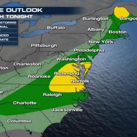
The storm system is expected to track eastward toward New Jersey and the Mid-Atlantic region through midweek, bringing rainfall rates exceeding 2 inches per hour and flash flood risks.
The National Weather Service said showers, thunderstorms, and humidity will return from Monday through at least Thursday, with potential for excessive rainfall leading to flash flooding, particularly on Tuesday.
>>> VW Motorsport Builds 1,000-HP Golf Hillclimb Car with Front Bumper Exhaust
Regional weather offices continue to monitor shifting conditions. High temperatures are expected to ease into the low 80s after the storm front passes.