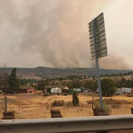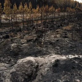
Raging wildfires and rare fire cloud phenomena continue to spread across southwestern France near Bordeaux and central Spain, while contrasting storms cause heavy flooding in central France and Greece.
The intense wildfires in France generated a pyrocumulonimbus cloud and fire tornadoes, exposing how severe atmospheric heat can create isolated, high-intensity systems alongside neighboring cold fronts.
How Fire Clouds Form
AccuWeather lead international forecaster Jason Nicholls detailed the mechanics behind the severe cloud structures forming over the fire zones.
"Wildfires give off intense heat, forcing large amounts of smoke and hot air to rise," said Nicholls.
"As the mixture moves higher it cools and expands as the air pressure drops. Moisture in the air condenses, forming clouds called pyrocumulus clouds."
These clouds rarely produce rain but can generate thunder and lightning, which makes them problematic, as lightning strikes can ignite new wildfires.
Nicholls noted that while fire tornadoes are far less frequent than dust whirlwinds, extreme ground heating drives their formation rapidly above large blazes.
"They're not really tornadoes at all, but a special type of whirlwind," he said. The rising hot air forces the surrounding atmosphere into a violent vertical rotation.
"Whirlwinds occur when the sun or fire heats dry terrain and causes a column of warm air to rise rapidly," said Nicholls.
"As it does, the column of air will whirl or rotate around a vertical axis.
They become visible when they pick up debris from the ground or, in the case of a fire tornado, pull flames up through this rotating column of air."
Contrasting Weather Systems
French emergency officials emphasized the extreme volatility caused by the rising atmospheric smoke stack over the region.
Eric Brocardi, spokesperson for the National Firefighters Federation of France, described the situation as "unprecedented in France."
"This smoke cloud generates its own weather system, causing anything in its path to spontaneously combust," said Brocardi.
Simultaneously, central France faces severe hailstorms with floodwaters submerging roadways under 40 centimeters of water, while midsummer snow fell on Mount Olympus in Greece.
Meteorologists explain that massive atmospheric energy releases naturally generate extreme contrasting weather conditions across European regions during summer months.
"Such widely varying contrasts in weather are dual in Europe during the summer months," said Dr. Simon Keeling, Weatherweb meteorologist and author.
"As heat builds, vast amounts of energy are released, and any available moisture, such as from a sea or lake, can build into huge thunderstorms."
Official meteorological agencies noted that violent storm activity frequently follows intense heat spells during weather system transitions.
"Extreme heat and nearby extreme flooding is a fairly standard meteorological set-up and we often see it when there's a transition from warm and settled weather to a new weather regime," said a spokesperson for the Met Office.
Recent regional observations show temperatures running significantly higher than typical seasonal benchmarks.
"What's notable is the temperatures well above average in the area – around 10C above normal for some and hot on the heels of similarly hot heatwaves in recent weeks," the spokesperson added.
Weather consultants point to jet stream fluctuations and airflows from Africa for driving the heatwave on one side of the continent while drawing cool northerly air down the other.
Jim Dale, founder and consultant meteorologist at British Weather Services, called it "quite a natural thing."
"Why? It's simply the airflow," said Dale.
"So, for the most part, on the Western side in Europe we've had high pressure, we've had airflow off Africa – so it's been a warm stroke, with hot airflow across increasingly very warm oceans.
On the other side of the coin, you've got the northerly flow.
That's a cool direction, and therefore you get the opposite: the cold and the freakish events across mountains where you might see a bit of snow in summertime."
Forecasts indicate the heatwave will expand across France, Spain, Germany, and Italy, maintaining high wildfire risks as rain remains sparse.
"Drought conditions will continue or worsen this week as rain chances look sparse," said Nicholls.
"There will also continue to be an extreme wildfire risk in western into central Europe."
French firefighters reportedly have 24 hours to gain control of the spreading fires before a 40°C heatwave hits the southwest region.