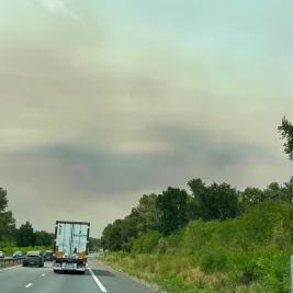

Raging wildfires and rare fire cloud phenomena continue to spread across southwestern France near Bordeaux and central Spain, while contrasting storms cause heavy flooding in central France and Greece.
The intense wildfires in France generated a pyrocumulonimbus cloud and fire tornadoes, exposing how severe atmospheric heat can create isolated, high-intensity systems alongside neighboring cold fronts.
>>> BBC Puts Blankety Blank on Hold as Bradley Walsh Cites Busy Schedule
How Fire Clouds Form
AccuWeather lead international forecaster Jason Nicholls detailed the mechanics behind the severe cloud structures forming over the fire zones.
"Wildfires give off intense heat, forcing large amounts of smoke and hot air to rise," said Nicholls.
"As the mixture moves higher it cools and expands as the air pressure drops. Moisture in the air condenses, forming clouds called pyrocumulus clouds."
These clouds rarely produce rain but can generate thunder and lightning, which makes them problematic, as lightning strikes can ignite new wildfires.
Nicholls noted that while fire tornadoes are far less frequent than dust whirlwinds, extreme ground heating drives their formation rapidly above large blazes.
"They're not really tornadoes at all, but a special type of whirlwind," he said. The rising hot air forces the surrounding atmosphere into a violent vertical rotation.
"Whirlwinds occur when the sun or fire heats dry terrain and causes a column of warm air to rise rapidly," said Nicholls.
"As it does, the column of air will whirl or rotate around a vertical axis.
They become visible when they pick up debris from the ground or, in the case of a fire tornado, pull flames up through this rotating column of air."